Friday, December 20, 2019

ACEER Conference: Mechanism of Sediment Transport by Flood and Longitudinal Peak Discharge Amplifications in the Yellow River


The 2019 International Conference on Advances in Civil and Ecological Engineering Research (ACEER 2019) was held successfully in Kaohsiung City, Taiwan, from July 1st - 4th, 2019. It was organized by I-Shou University, co-organized by National Sun Yat-Sen University, National Kaohsiung University of Science and Technology, and Taiwan Society of Microbial Ecology. The technical program comprised one plenary session with 2 keynote speeches, seven parallel sessions including 22 invited speeches and 37 regular oral presentations, and 23 poster presentations. ACEER 2019 aimed to provide a high-level international forum for researchers and engineers to present and discuss recent advances, new techniques and applications in the field of Civil Engineering, Environmental and Ecological Engineering. This conference has attracted around 120 participants from 15 countries and areas. The subjects of the conference included many disciplines or inter disciplines of civil engineering, ecology and environment.

Home page - ACEER2020

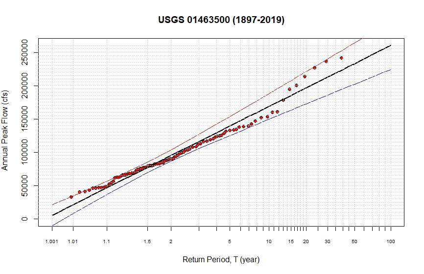
Abstract of my presentation: As a general principle of river bed evolution during the fluvial process, the channel is formed by river flows, while the movement of river flows is contained by channels. When the hyperconcentrated flood propagates along the wandering reach of the Yellow River, the peak discharge of the flood can increase along the reach. Due to the recurrence of this abnormal phenomenon, attentions have been drawn from various stakeholders, since the amplifications of flood peak can jeopardize flood control works. By analyzing the field observed data, we present our research findings of "scour during rising” and “deposit during falling” of a flood event, as well as the sediment transport mechanism with constant discharge. The bedform affects the characteristics of sediment transport and the resistance force. When the bedform is in the dynamic equilibrium state, sediment transport characteristics can be described as “the more sediment input, the more sediment output”. When the shear stress created by flow acting on bed is increasing, scour is observed on the channel bed. On the contrary, when shear stress is decreasing, deposition is observed. When the shear stress remains the same, sediment transport is in the equilibrium state. After the operation of Xiaolangdi Reservoir, due to coarsen of the bed material, the bedform resistance increased. When the flow condition changes and the bed roughness decreases abruptly, the increasing flow velocity can result in the reduction of channel storage volume. This is the main reason for the longitudinal amplifications of peak discharge in the wandering reach of the Yellow River.

The full paper can be found here:


Thursday, November 14, 2019

Google Earth Engine (GEE) Produced March 2019 Omaha Flooding Map

I used Google Earth Engine to produce a map of Omaha NE flooding of March 2019 based on the EU's Sentinel-2 image. Google Earth Engine (GEE) is a cloud-based platform for planetary-scale environmental data analysis. The main components of the Earth Engine are: Datasets: A petabyte-scale archive of publicly available remotely sensed imagery and other data. As a cloud-based geospatial analysis platform,  the powerful tool of GEE enables users to visualize and analyze satellite images of our planet. Scientists and non-profits use Earth Engine for remote sensing research, predicting disease outbreaks, natural resource management, and more. Also students can access this information to join the discussion and become data scientists themselves.

Some background of this flooding event: the Midwestern United States experienced major floods in the Spring of 2019, primarily along the Missouri River and its tributaries in Nebraska, Missouri, South Dakota, Iowa, and Kansas. The Mississippi River also saw flooding, although starting later and ending earlier. The 2019 January-to-May period was the wettest on record for the U.S., with multiple severe weather outbreaks through May in the Midwest, High Plains, and South exacerbating the flooding and causing additional damage. Throughout late May and early June, rain in Iowa, Illinois, and Missouri caused every site on the Mississippi River to record a top-five crest. At least three people in Iowa and Nebraska have died. Nearly 14 million people in the midwestern and southern states have been affected by the flooding, which the New York Times has called "The Great Flood of 2019". New record river levels were set in 42 different locations. Although $12 billion in aid was made "available to farmers who lost money due to the trade war" the previous year, Reuters reported that the USDA had "no program to cover the catastrophic and largely uninsured stored-crop losses from the widespread flooding." At least 1 million acres of U.S. farmland, in nine major grain-producing states, have flooded.


Sunday, October 20, 2019

USGS R Packages for Stream Gauge Analysis

This is a very nice collection of the USGS R training curriculum, and materials that correspond to specific workshops. The current courses are Introduction to R, Introduction to USGS R Packages, and R Package Development.

 
Introduction to R Languages can be found here:
https://owi.usgs.gov/R/training-curriculum/intro-curriculum/.

I also developed a sample R program to analyze the flood recurrence interval based on annual peak discharge (cfs), and Log-Pearson Type III distribution at USGS 01463500 Delaware River at Trenton NJ:
### STEP 1
### Removing all previously generated datasets and plots 
cat("\014")
rm(list = ls())
dev.off()

### STEP 2
### Loading two specific packages into Program
library(dataRetrieval) 
library(xts)

### STEP 3
### Get the Peak Annual Discharge at USGS Delaware River at Trenton, NJ
mysite<-'01463500'
annualpeak<-readNWISpeak(mysite)

### STEP 4
### Perform Flood Frequency Analysis 
Q_peak = as.numeric(annualpeak$peak_va)
Q <- na.exclude(Q_peak)
graphlab = "(1897-2019)"

#Generate plotting positions
n = length(Q)
r = n + 1 - rank(Q)  # highest Q has rank r = 1
T = (n + 1)/r

# Set up x-axis tick positions and labels
Ttick = c(1.001,1.01,1.1,1.5,2,3,4,5,6,7,8,9,10,11,12,13,14,15,16,17,18,19,20,25,30,35,40,45,50,60,70,80,90,100)
xtlab = c(1.001,1.01,1.1,1.5,2,NA,NA,5,NA,NA,NA,NA,10,NA,NA,NA,NA,15,NA,NA,NA,NA,20,NA,30,NA,NA,NA,50,NA,NA,NA,NA,100)
y = -log(-log(1 - 1/T))
ytick = -log(-log(1 - 1/Ttick))
xmin = min(min(y),min(ytick))
xmax = max(ytick)

# Fit a line by method of moments, along with 95% confidence intervals
KTtick = -(sqrt(6)/pi)*(0.5772 + log(log(Ttick/(Ttick-1))))
QTtick = mean(Q) + KTtick*sd(Q) 
nQ = length(Q)
se = (sd(Q)*sqrt((1+1.14*KTtick + 1.1*KTtick^2)))/sqrt(nQ) 
LB = QTtick - qt(0.975, nQ - 1)*se
UB = QTtick + qt(0.975, nQ - 1)*se
max = max(UB)
Qmax = max(QTtick)

# Plot peak flow series with Gumbel axis
plot(y, Q,
     ylab = expression( "Annual Peak Flow (cfs)" ) ,
     xaxt = "n", xlab = "Return Period, T (year)",
     ylim = c(0, Qmax),
     xlim = c(xmin, xmax),
     pch = 21, bg = "red",
     main = paste( "USGS 01463500",graphlab )
)  
par(cex = 0.65)
axis(1, at = ytick, labels = as.character(xtlab))

# Add fitted line and confidence limits
lines(ytick, QTtick, col = "black", lty=1, lwd=2)  
lines(ytick, LB, col = "blue", lty = 1, lwd=1.5)
lines(ytick, UB, col = "red", lty = 1, lwd=1.5)  

# Draw grid lines
abline(v = ytick, lty = 3, col="light gray")             
abline(h = seq(500, floor(Qmax), 5000), lty = 3,col="light gray") 
par(cex = 1)

### STEP 5
# Also show regression equations for Q~T
model <- lm(QTtick~ytick)
paste('Q =', coef(model)[[2]], '* ln(T)', '+', coef(model)[[1]])
paste('T =', 'EXP ( (Q  - ', coef(model)[[1]], ') / ', coef(model)[[2]], ')')

Wednesday, September 18, 2019

Prof. Qi Pu Invited to Popular TV Show of "Only You" (Tianjin TV)

Professor Qi Pu participated in the silver-hair section of the popular TV show, "Only You" of Tianjin Satellite TV in May 2018. Professor Qi Pu, 76 years old, is from the Lower Yellow River, near Zhengzhou, Henan Province in Central China. Since the 1960s, he has been committed to the research and governance of the Yellow River. He has presided over the Yellow River related Science-Technology Project of the National '8th Five-Year-Plan' of China, and won the second prize of scientific and technological progress in Henan Province. As the role model in his position, he was warmly received by the national and provincial leaders. During the show, Professor Qi Pu said: "The Yellow River has changed dramatically, and it's my sincere life-long wish that this river will no longer flood in the future."