Exceptionally High Seasonal Rainfall Scenario over Kerala
According to the Indian Meteorological Department (IMD), rainfall over Kerala during southwest monsoon season of 2018 (June 1 to August 20, 2018) has been exceptionally high. Kerala so far received 2378.7 mm (94 inches) against normal of 1676.3 mm (70 inches, above normal by 42%). Highest excess rainfall is recorded over Idukki District (92% above normal) followed by Palakkad (72% above normal). The rainfall frequency-intensity-duration analysis showed that:
· The rainfall over Kerala has been in general above normal throughout the season.
· The rainfall over Kerala during June, July has been 15%, 18% above normal respectively as shown in the Table.
· Rainfall during August 2018 (till August 19) so far has been exceptionally high (164%).
· Especially, there were two consecutive active spells with above normal rainfall peaking around June 14 and 20 respectively. Another peak rainfall activity was experienced around July 20.· Heavy daily rainfall was observed (70 mm or more) from August 10 to 16.
Table 1. Rainfall over Kerala during Monsoon Season - 2018


Source: Indian Meteorological Department (IMD)

Cumulative Rainfall Map for India from August 10 to 16 (Source: IMD)

Rainfall Analysis for Kerala - SW Monsoon Season 2018 (Source: IMD)
Due to heavy rainfall scenario prevailed till end of July, 2018 over Kerala, all of major 35 odd reservoirs storage was close to the full reservoir level (FRL) and had no buffer storage to accommodate the heavy inflows from August 10. The continued exceptional heavy rainfall in August (with 170% above normal so far) in the catchment areas had compelled the authorities to resort to heavy releases downstream into the rivers.
Such a scenario that continued for almost a week now has caused overflowing of all river banks leading to widespread flooding almost all over the state. All the 35 out of the 42 dams within the state were opened for the first time in history, and all five overflow gates of the Idukki Dam (water level of 732 meters, or 2,403 feet) were opened at the same time after a gap of 26 years.
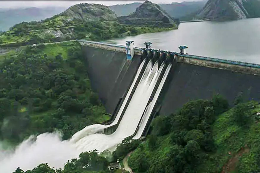
A View of Water Released from All Five Sluice Gates of Idukki Dam in Kerala (Source: Press Trust of India)
Flood Affected Areas and Disaster Relief Efforts
National Disaster Management Authority of India (NDMA) reported that the total flooded area increased from 28,737 hectares on August 14 to 50,119 hectares on August 17. The Chief Minister said that 24,948 hectares were flooded in Alappuzha and 14,006 in Kottayam districts. As of now, the Indian Army has deployed 18 teams, Navy 46, Air Force 13, Coast Guard 18 and National Disaster Response Force 21. Meanwhile, the Air Force has deployed 18 choppers, NDRF 79 boats and state fisheries department 403 boats. Also, the state police have deputed 40,000 personnel for rescue and relief activities. Indian Prime Minister Narendra Modi expressed grief and sorrow on the unfortunate deaths and damage, during his visit to the flood affected areas on August 18.

Kerala Flooding Map as of August 18, 2018 (inundation area in cyan color)
(Image: NRSC (2018) - Flood Inundated areas in parts of Kerala State DSC/NDEM NRSC/ISRO, Hyderabad)

Aerial View and Rescue Efforts of Kerala Flood (Source: National Disaster Management Authority of India)
Rainfall Intensity Reduced and Floods Receding
The India Meteorological Department (IMD) said the intensity of rainfall in the state would reduce in the next three to four days. “Kerala is not expected to receive heavy rainfall from August 20,” said by additional director general of IMD. The heavy rain started easing, and flood waters are slowly receding in some areas. The Cabinet Secretary PK Sinha of National Crisis Management Committee (NCMC) said the focus should now be placed on provisions of emergency supplies of food, water, medicines and restoration of essential services such as power, fuel, telecommunications and transport links, as flood water retreats. In the fear of increased disease following the wake of the flooding, medical teams have been established as well as medical relief camps to help flood victims.
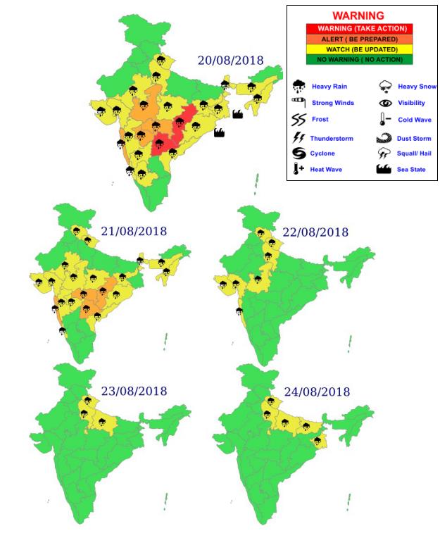
Rainfall Forecast Map for India, Week of August 20, 2018
(Source: Indian Meteorological Department)
Brief Summary of Estimated Flood Losses on Properties, Agriculture and Tourism
According to Mirror Now, an English-language news channel owned by The Times Group, India’s largest media conglomerate, the estimated flood losses for this event are summarized as below:
- Chief Minister of Kerala pegged the value of losses at roughly INR 19,512 crore (2.8 billion USD)
- Losses to the tune of INR 8,316 crore (1.2 billion USD) have been faced, reports by Press Trust India (PTI)
- Approximately 8,000 houses have been washed away, and around 26,000 are partly damaged.
- Tea, coffee cardamom and rubber plants have run up losses of INR 600 crore (86 million USD)
- An estimated loss of tea plantations is between INR 150 crore to INR 200 crore (29 million USD)
- Kottayam, the state's 'rubber belt' is facing extensive crop loss of INR 35.07 crore (5 million USD)
- Tourism has also taken a major hit with 70 - 80% cancellations as per Indian Association of Tour Operators or Indian Association of Tour Operators (IATO)
- More than 10,000 kilometers (6.2k miles) of roads and bridges have been damaged.
The flooded area produced by Google Earth Engine can be seen from here: https://mdm.users.earthengine.app/view/kerala-flood-2018.