Tuesday, September 13, 2016

Louisiana Flood in August 2016 - Flood Footprints in Baton Rouge, LA

The largest flood loss driver of 2016 was the Louisiana flood in August 2016.  With NOAA estimating $10B in economic loss, the meteorological statistics from this event were nothing short of staggering.  Baton Rouge, LA registered 26.97” of rain in August, with over 20” falling in a 48 hour period; the monthly rainfall total broke the prior record of 23.73” in May 1907.  Moreover, 20” in a 48 hour period registered well in excess of a 1,000 (500?) year period recurrence interval for this region.  The impacts were widespread and historic, with river levels cresting at record heights, including the Amite River at Denham Springs cresting at 46.2’, over 5 feet higher than the prior record in April 1983.  

I analyzed this event due to the wide ranging impacts. Based on a 5 by 5 meter resolution Digital Elevation Model (DEM) with lots of city level of details such as buildings and highways, JLT Re performed the 4-day rainfall-runoff simulations and obtained the flood footprint by using Hydrologic Engineering Center’s River Analysis System (HEC-RAS), United States Army Corps of Engineers. As it can be seen from the exhibit below, not only does the resulting map show the inundation extents (blue), but it also illustrates the spatially varied flood depth (in feet), which is a key factor to determine the flood severity, as well as the exposure and vulnerability analysis. Many locations (yellow dots) shown as being inundated during this event, such as Louisiana State University (LSU) Campus, I-10/I-12 from LA 73 (Prairieville, LA)  to Siegen Lane, US 190 in Merrydale, etc, have all been verified with field photos taken by Civil Air Patrol. JLT Re also validated the result with FEMA hazard GIS layer (light red) published one month later after the event, and found out they are in very good agreement.


Tuesday, August 16, 2016

The Forming Conditions of Alluvial River Channel Patterns

[Abstract] In the normal fluvial process, the river channel is determined by river flows while the movement of river flow is contained by river channels. The relationship between the river morphology and its bend curvature shows that rivers with large bend curvatures always have narrow and deep channels and those with shallow and wide channels are always straight. The plan form of a river reaches is determined by the cross-sectional morphology. A meandering river reach may be developed under various water-sediment conditions as long as the narrow and deep channels are formed.


To read the full technical paper, please read at my researchgate websitie:
https://www.researchgate.net/publication/262911265_The_Forming_Conditions_of_Alluvial_River_Channel_Patterns.


Wednesday, July 20, 2016

Successful Reconstruction of 1993 Great Mississippi River Flood Footprint

The 1993 Midwest flood was one of the most significant and damaging natural disasters ever to hit the United States. Damages totaled $15 billion, 50 people died, hundreds of levees failed, and thousands of people were evacuated, some for months. The flood was unusual in the magnitude of the crests, the number of record crests, the large area impacted, and the length of the time the flood was an issue. The paper discusses some details of the flood, the forecasting procedures utilized by the National Weather Service and the precipitation events which caused the flood.

From May through September of 1993, major and/or record flooding occurred across North Dakota, South Dakota, Nebraska, Kansas, Minnesota, Iowa, Missouri, Wisconsin, and Illinois. Fifty flood deaths occurred, and damages approached $15 billion. Hundreds of levees failed along the Mississippi and Missouri Rivers. The magnitude and severity of this flood event was simply over-whelming, and it ranks as one of the greatest natural disasters ever to hit the United States. Approximately 600 river forecast points in the Midwestern United States were above flood stage at the same time. Nearly 150 major rivers and tributaries were affected. It was certainly the largest and most significant flood event ever to occur in the United States (Fig. 1).


A Depth Grid is GIS format data that represents the extent of riverine flooding or coastal storm surge inundation and the depth of water at a given location. Depth Grids are commonly delivered in raster ESRI GRID format, each pixel contains a value representing potential water depth. Factors that contribute to the resolution or level of detail displayed by a depth grid are twofold. These factors include resolution of your terrain data, and availability of flood surface elevation information.

Depth Grid accuracy is dependent on the resolution of the Digital Elevation Model (DEM) or terrain data used during the processing of a Depth Grid. Secondly, the method used for collecting information on the elevation of your flood surface may vary. Common methods for generating flood surface information are: the use of High Water Mark (HWM) data, the use of BFE (Base Flood Elevation) cross sections, or local H&H (Hydrology and Hydraulics) models. Determining the resolution requirements for a Depth Grid is reliant on the type of analyses that will be conducted with the processed Depth Grid. For example, when site specific (structure by structure) analyses are needed for loss estimation, higher resolution elevation datasets are more appropriate, whereas if to gain a general idea of flood extent is the intent, a lower resolution elevation dataset would be adequate.


Monday, May 30, 2016

Yellow River Facts — Mother Monster Tamed

The Yellow River overflows with shocking facts. China's "Mother River" gave a home to early civilization, then regularly devastated it with deadly floods and course shifts. China's recent infrastructure boom has fully harnessed the Yellow River for hydroelectricity, reservoirs, irrigation, etc., turning the "monster" into a natural resource.

Sixth Longest River - Huge Torrent to Muddy Trickle

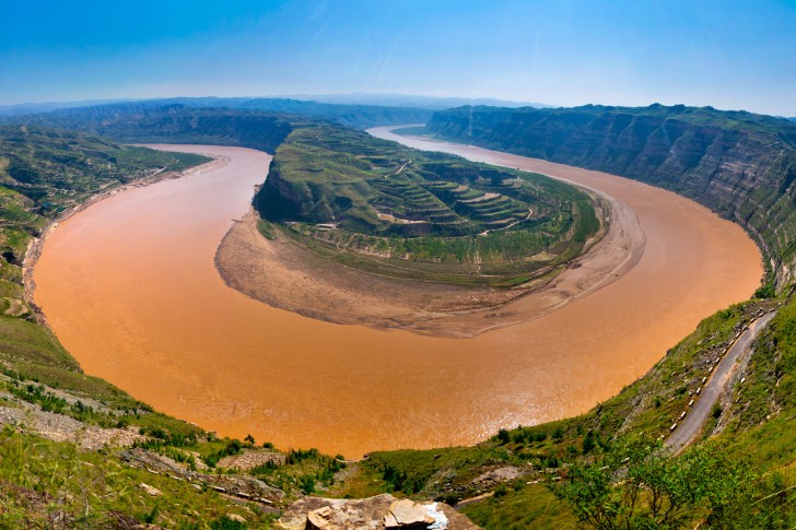
The first bay of the yellow riverThe First Bend of the Yellow River on the Sichuan-Gansu border
The Yellow River, is the second longest river in China after the Yangtze, and the sixth longest in the world, but less than the 100th for discharge. It dominates dry northern China. Unlike other rivers, it seems to decrease in flow as it goes.
Length: 5,464 km (3,398 mi)
Source: the Bayankala Mountains, Qinghai Province, western central China
Mouth: the Bo Sea at Shandong Province, a gulf on the East China Sea
Read more on Yellow River Geography.

Cradle of Chinese Civilization

Chinese people say the Yellow River is "the Mother River of China" and "the Cradle of Chinese Civilization". Historical evidence shows that the lower Yellow River basin was where Chinese civilization began, and the most prosperous region in early Chinese history.
Zhoukoudian Anthropological Museum
Peking Man statue at Zhoukoudian Anthropological Museum in Beijing
Prehistoric Chinese lived just north of the Yellow River Basin at Zhoukoudian, south of Beijing, and around Sanmenxia on the Yellow River, midway between Xi'an and Zhengzhou. It was around Zhengzhou that the earliest Chinese dynasties were based: the Xia (2100–1600 BC, capital Luoyang) and Shang (1600–1046 BC, capital Anyang) dynasties. Xi'an, on the Wei tributary of the Yellow River, was a prominent Chinese capital in several dynasties from the Qin Dynasty (221–206 BC) to the Tang Dynasty (618–907). The Yellow River Basin was the center of Chinese politics, economy, culture, and innovation for about 3,000 years.

The Muddiest Major River on Earth

  • Chinese name: 黄河 Huánghé /hwung-her/ ‘Yellow River' 
  • Alternative Chinese name: 浊河 Zhuóhé /jwor-her/ 'Muddy River'
The Yellow River got its name because of the ochre-yellow color of the muddy water in the lower reaches of the river. Each year, the river carries 1.6 billion tons of fine sediment (loess) when its middle reaches flows through China's Loess Plateau region. It carries more sediment per cubic meter than any other major river in the world, and deposits most of it long before it reaches the delta.

The World's Largest "Yellow" Waterfall — Hukou Waterfall

Hukou WaterfallHukou Waterfall — the most sedimented major waterfall in the world
Hukou Waterfall, in the middle reaches of the Yellow River, is the largest "yellow" waterfall in the world, and the second largest waterfall in China after Huangguoshu Waterfall. The waterfall is named Hukou (壶口 /hoo-co/ ‘Kettle Mouth’) because the riverbed there has eroded into a spout like an enormous teapot, from which the rushing "yellow" water pours out. When the mighty Yellow River flows through the gorge at Hukou, it abruptly narrows, turning the water into rapids, ending in thundering chocolaty billows. The magnificent waterfall is 15 meters (50 feet) high and 30 to 50 meters (100–160 feet) wide, depending on the season. The marvelous scene of Hukou Waterfall attracts numerous tourists every year. Learn more about Hukou Waterfall.

Ships Sail on a Raised River — 10m Above the Ground!

Usually, a river is the lowest point around — not so with the Yellow River! Due to sediment accumulation, and successive levees built to contain the raised flow, the riverbed is up to 10 meters (33 feet) above the surrounding cities and farmlands in most of its lower reaches. So it is also called "the Hanging River" or "Above Ground River". The Yellow River is the only river where ships sail overhead!

"China's Sorrow" Has Killed Millions by Flooding

Because of the continual rise of the riverbed caused by the accumulated silt, the river tends to overflow its banks, and sometimes leave its banks far behind (see below). Surrounding areas were extremely prone to flooding and river course change. The Yellow River has long been known as "China's Sorrow." It was the most destructive and dangerous river in the world, until damming and massive abstraction has reduced it to a carefully controlled trickle. Between 602 B.C. and 1946, it has flooded 1,593 times, each time killing thousands by drowning, disease, starvation, and loss of livelihood. The 1931 Yellow River Flood was the most devastating natural disaster ever recorded, killing 1–4 million (apart from famines and plagues).

Over 20 Major Moves — from Tianjin to Shanghai

3,000 years ago the Yellow River emptied into the Bo Sea near Tianjin and Beijing, 200 km north of where it does now. But in the last 1,000 years (and as recently as 1947) it has emptied into a tributary of the Yangtze, flowing out at Shanghai — 600 km south of its current delta. It has changed its course dramatically an average of about once every 100 years, causing huge devastation.

Reduced to Nothing Annually Since 1972

Due to decrease in rainfall in the Yellow River catchment, and increased demands for irrigation, etc., the lower reaches of the Yellow River dried up completely for the first time in 1972, and since then have dried up almost annually. When it dries up, over 140 million people and about 74,000 km² (46,000 mi2) of farmland are affected. In 1996, the dry period persisted for 136 days, and 226 days in 1997.

Billions Spent on Flood Control

Strengthening and building higher embankments (and dredging) protect the surrounding areas from the rising river. Building large-scale water conservation projects, including Sanmenxia Reservoir and Xiaolangdi Multipurpose Dam to control flow and sediment deposition downstream, captures excess water when needed. Planting trees in the watershed reduces erosion and resulting sedimentation, and runoff rates. Damming tributaries of the Yellow River also slows the river's flow.

Wednesday, April 20, 2016

Hazard Mitigation Related to Water and Sediment Fluxes in The Yellow River Basin, China, Based on Comparable Basins of the United States


United States Geological Survey (USGS) 
W. R. Osterkamp1 and J. R. Gray2

1.Research Hydrologist, U.S. Geological Survey, Tucson, Arizona, 

2. Hydrologist, U.S. Geological Survey, Reston, Virginia

ABSTRACT: The Yellow River, north-central China, and comparative rivers of the western United States, the Rio Grande and the Colorado River, derive much of their flows from melting snow at high elevations, but derive most of their sediment loads from semiarid central parts of the basins. The three rivers are regulated by large reservoirs that store water and sediment, causing downstream channel scour and, farther downstream, flood hazard owing to re-deposition of sediment. Potential approaches to reducing continuing bed aggradation and increasing flood hazard along the lower Yellow River include flow augmentation, retirement of irrigation that decreases flows and increases erosion, and re-routing of the middle Yellow River to bypass large sediment inputs of the Loess Plateau. 


Proposals to modify or induce flooding in the lower Yellow River date from at least the 1960s (Qi, 1997). The general concept of controlled flows to rehabilitate river lowlands, such as controlled releases to the Colorado River from Lake Powell (fig. 2), can be an effective management tool for any large river (Marzolf and others, 1999). A benefit of approach 5 is that releases from Liujiaxia Hydropower Station can be based on Yellow River flow, consumptive needs in the middle basin, and the need to reduce bed elevation along the lower reach of the river. During periods of low runoff, for example, most flow would discharge from Liujiaxia Hydropower Station into the Yellow River, whereas during times of higher flow, and especially during flood, much of the flow would be diverted through the Tao He into the Wei He to maximize scour in the lower reach of the Yellow River. Use of adaptive management, therefore, could not only continue to provide adequate flow to the middle Yellow River, but also could reverse bed aggradation in the lower reach.

The net long-term advantages for the well-being of the people and agricultural production of the Yellow River Basin may be greatest if approach 5 is considered. This approach seems most likely to offer lasting protection for life and resources of the lower basin while minimizing adverse effects of the upper and middle basin. Importation of water from the Yangtze River has the same advantage of flushing stored sediment from the lower Yellow River Valley, but may include negative features, such as future economic (political) imbalances of water distribution and disruption of regional ecological systems.   


Citation of My Publication:  Qi, Pu, 1997, Effect of perennial sediment regulation in Xaiolangdi Reservoir on reduction of the deposition in the lower Yellow River, International Journal of Sediment Research, v. 12, no. 2, p. 58-67.

Full Paper can be downloaded at:

Wednesday, March 23, 2016

International Research and Training Center on Erosion and Sedimentation in Beijing (IRTCES)

Sedimentation problems are a matter of global concern. According to a preliminary statistics, the annual erosion of surface soil from global river basins amounts to 60 billion tons; as much as 5 to 7 million ha of farmland are annually ruined and about 1% of the precious storage capacity of the world's reservoirs is annually lost to deposition, which causes aggravation of flood and drought disasters and deterioration of ecology and environment. Therefore, there was an urgent need to establish an international center to strengthen the research and training activities and technical co-operation among the member states of UNESCO in the field of erosion and sedimentation. UNESCO certified the feasibility of establishing a center in 1981, and concluded that it was suitable to establish it in China.


The International Sediment Initiative is expected to add a new dimension to ongoing efforts aiming at sustainable sediment management, in the context of sustainable water resources development at global scale. Hence, its mission directly relates to the commitments of the international community expressed in major documents such as the Millennium Development Goals, the Rio Declaration of Sustainable Development, the World Water Assessment Programme, World Water Development Reports, etc. By its activity, the International Sediment Initiative aims to uphold the importance of sustainable sediment management within the context of the two United Nations decades which have set-up in 2005: the 'Water for Life Decade' and the 'Decade for Education for Sustainable Development'. With direct access to stakeholders represented in the IHP National Committees and the Intergovernmental Council, ISI should be viewed as a vehicle to advance sediment management at the global scale.

International Research and Training Center on Erosion and Sedimentation in Beijing (IRTCES) website: http://www.irtces.org/irtces/index.htm.

UNESCO International Sediment Initiative: Case Study on the Yellow River Sedimentation, 
http://www.irtces.org/isi/isi_document/CaseStudy_Yellow_River_IRTCES1.pdf.


Monday, February 8, 2016

Fireworks on Hudson River for Chinese New Year 2016

NEW YORK (CBS New York) — New York City will be celebrating the Lunar New Year with a five-day festival in early February.

“The Year of the Monkey Celebration” runs from Feb. 6 through Feb. 10. The festival, presented by the China Central Academy of Fine Arts, is hosting a myriad of events, including the “The Fantastic Art China” exhibition at the Javits Center, where traditional and contemporary Chinese artworks will be showcased. Environmental conservation efforts for monkeys in China also will be highlighted. 

A Hudson River fireworks display set to the music of Oscar and Grammy Award winner Tan Dun is scheduled for Feb. 6.The Empire State Building is also planning a light display for Feb. 6 and Feb. 8. And the New York Philharmonic’s 5th Annual Chinese New Year Concert will be held at Lincoln Center on Feb. 9.