The Loess Plateau covers around 640,000 square kilometers in northwest China and has among the world's most elevated soil disintegration rates. Characterized fine dry soil (called loess) and hundreds of years of unsustainable cultivating rehearse, joined with immense populace weights, have prompted extreme ecological debasement. Generally speaking, 1.6 billion tons of residue deposits in the Yellow River every year, and represent a genuine downstream surge chance. As of late, be that as it may, the discontinuity of cultivating on steep slopes and the foundation of expansive scale terracing and dregs control structures have made noteworthy strides in fighting off further degradation.
Reference reading for China Erosion and Sedimentation materials:
Since 2010, Yongchen Wang, a senior reporter and mediator of the Central People’s Broadcasting Station, has organized a long-distance trip along the Yellow River every year. The purpose of this trip is to witness, record and expose the ecological crisis along the Yellow River. In addition to environmental volunteers participating in this self-driving trip, it also includes media reporters. Wang Yongchen plans to go through the Yellow River every year for ten consecutive years. From the Yellow River estuary in Dongying, an industrial city on the eastern coast of China, to the source of the Yellow River in the Qinghai-Tibet Plateau, which is inaccessible, records the ten-year changes of the mother river's ecological environment, especially the water pollution.
Professor Pu Qiintroduced the Yellow River to the participants of this event at Huayuankou in 2018. With the progress of the water and soil conservation project in the upper and middle reaches, the use of the Xiaolangdi in the middle reaches has been implemented, and the riverbed in the lower Yellow River has not been raised. He introduced the latest situation of the lower Yellow River and answered the questions from the audience. At the same time, analogous to the arid rivers in North China, such as the Juma River in Hebei Province, the Weihe River in Shanxi Province, and the Yongding River in Beijing, there have been dramatic changes in water and sand in recent decades, and no floods have occurred. According to the statistics of the Ministry of Science and Technology, two-thirds of the rivers in the northern region have already become dry rivers. Professor Pu Qifully proved that "the Yellow River has undergone tremendous changes, and floods will never occur."
Professor Pu Qialso introduced the situation of the Yellow River at the estuary and answered everyone's questions. 90% of the sediments of the Yellow River come with the flood. The amount of sand in the dry season is very small. As long as the reservoir is used well, it is necessary to adjust the sediment for many years and make full use of the flood discharge to benefit the reservoir. The Ministry of Water Resources has achieved the goal of macroscopic management of the lower reaches of the Yellow River, such as “unbreached dikes, continuous flow of rivers, water quality not exceeding standards, and riverbeds not rising”. From May 14th news on the Yellow River Institute of Hydraulic Research (Zhonghongwang.com of Beijing), Pu Qi recently wrote the article "The riverbed in the lower Yellow River has not been raised." The author believes that the trend of water and sediment caused by the treatment of the upper and middle reaches of the Yellow River has caused a drastic change in the flood control situation of the downstream channels. The downstream flood flow and the amount of sand have been gradually reduced, and the amount of sand transported to the estuary has also been greatly reduced. The siltation extension is weakened and its influence on the upstream river channel is negligible.
The author emphasizes that in order to prevent problems in the over-managed of rivers in North China, causing the environment in the lower Yellow River to deteriorate and maintain the healthy life of the Yellow River, "Wide River Harnessing Plan" should be revised as soon as possible.
From late July to August 2018, severe flooding affected the southern Indian state of Kerala due to unusually high rainfall during the monsoon season. Kerala faces the worst flood in over 100 years, with over 50,119 hectares of land being inundated. Over 370 people died, 38 people missing, and at least 780,000 were displaced in 5,645 relief camps, and all 14 districts of the Kerala state, were placed on high alert. The Chief Minister of Kerala, Mr Pinarayi Vijayan, pegged an estimated flood loss at roughly INR 19,512 crore (2.8 billion USD).
Exceptionally High Seasonal Rainfall Scenario over Kerala According to the Indian Meteorological Department (IMD), rainfall over Kerala during southwest monsoon season of 2018 (June 1 to August 20, 2018) has been exceptionally high. Kerala so far received 2378.7 mm (94 inches) against normal of 1676.3 mm (70 inches, above normal by 42%). Highest excess rainfall is recorded over Idukki District (92% above normal) followed by Palakkad (72% above normal). The rainfall frequency-intensity-duration analysis showed that:
· The rainfall over Kerala has been in general above normal throughout the season.
· The rainfall over Kerala during June, July has been 15%, 18% above normal respectively as shown in the Table.
· Rainfall during August 2018 (till August 19) so far has been exceptionally high (164%).
· Especially, there were two consecutive active spells with above normal rainfall peaking around June 14 and 20 respectively. Another peak rainfall activity was experienced around July 20.· Heavy daily rainfall was observed (70 mm or more) from August 10 to 16.
Table 1. Rainfall over Kerala during Monsoon Season - 2018
Source: Indian Meteorological Department (IMD)
Cumulative Rainfall Map for India from August 10 to 16 (Source: IMD)
Rainfall Analysis for Kerala - SW Monsoon Season 2018 (Source: IMD)
Due to heavy rainfall scenario prevailed till end of July, 2018 over Kerala, all of major 35 odd reservoirs storage was close to the full reservoir level (FRL) and had no buffer storage to accommodate the heavy inflows from August 10. The continued exceptional heavy rainfall in August (with 170% above normal so far) in the catchment areas had compelled the authorities to resort to heavy releases downstream into the rivers.
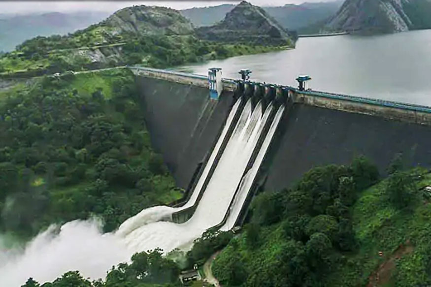
Such a scenario that continued for almost a week now has caused overflowing of all river banks leading to widespread flooding almost all over the state. All the 35 out of the 42 dams within the state were opened for the first time in history, and all five overflow gates of the Idukki Dam (water level of 732 meters, or 2,403 feet) were opened at the same time after a gap of 26 years.
A View of Water Released from All Five Sluice Gates of Idukki Dam in Kerala (Source: Press Trust of India)
Flood Affected Areas and Disaster Relief Efforts
National Disaster Management Authority of India (NDMA) reported that the total flooded area increased from 28,737 hectares on August 14 to 50,119 hectares on August 17. The Chief Minister said that 24,948 hectares were flooded in Alappuzha and 14,006 in Kottayam districts. As of now, the Indian Army has deployed 18 teams, Navy 46, Air Force 13, Coast Guard 18 and National Disaster Response Force 21. Meanwhile, the Air Force has deployed 18 choppers, NDRF 79 boats and state fisheries department 403 boats. Also, the state police have deputed 40,000 personnel for rescue and relief activities.Indian Prime Minister Narendra Modi expressed grief and sorrow on the unfortunate deaths and damage, during his visit to the flood affected areas on August 18.
Kerala Flooding Map as of August 18, 2018 (inundation area in cyan color)
(Image: NRSC (2018) - Flood Inundated areas in parts of Kerala State DSC/NDEM NRSC/ISRO, Hyderabad)
Aerial View and Rescue Efforts of Kerala Flood (Source: National Disaster Management Authority of India)
Rainfall Intensity Reduced and Floods Receding
The India Meteorological Department (IMD) said the intensity of rainfall in the state would reduce in the next three to four days. “Kerala is not expected to receive heavy rainfall from August 20,” said by additional director general of IMD. The heavy rain started easing, and flood waters are slowly receding in some areas. The Cabinet Secretary PK Sinha of National Crisis Management Committee (NCMC) said the focus should now be placed on provisions of emergency supplies of food, water, medicines and restoration of essential services such as power, fuel, telecommunications and transport links, as flood water retreats. In the fear of increased disease following the wake of the flooding, medical teams have been established as well as medical relief camps to help flood victims.
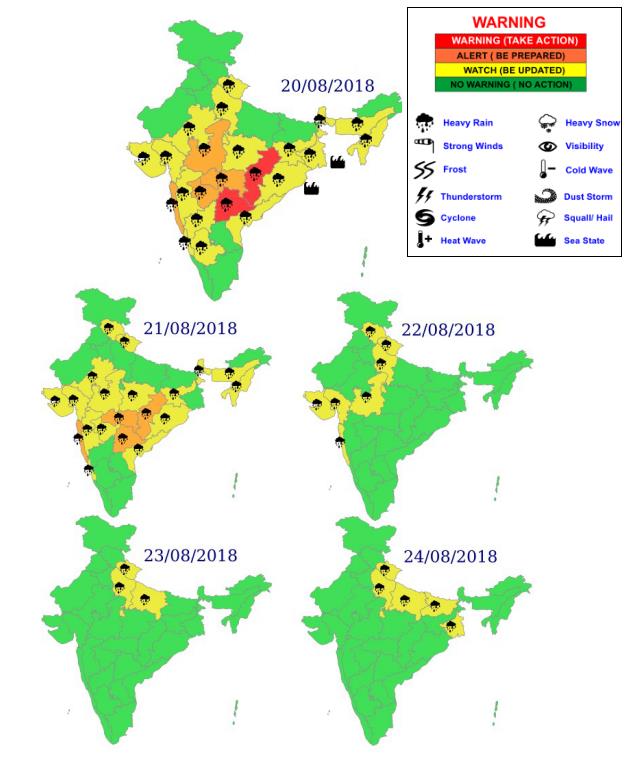
Rainfall Forecast Map for India, Week of August 20, 2018
(Source: Indian Meteorological Department)
Brief Summary of Estimated Flood Losses on Properties, Agriculture and Tourism
According to Mirror Now, an English-language news channel owned by The Times Group, India’s largest media conglomerate, the estimated flood losses for this event are summarized as below:
Chief Minister of Kerala pegged the value of losses at roughly INR 19,512 crore (2.8 billion USD)
Losses to the tune of INR 8,316 crore (1.2 billion USD) have been faced, reports by Press Trust India (PTI)
Approximately 8,000 houses have been washed away, and around 26,000 are partly damaged.
Tea, coffee cardamom and rubber plants have run up losses of INR 600 crore (86 million USD)
An estimated loss of tea plantations is between INR 150 crore to INR 200 crore (29 million USD)
Kottayam, the state's 'rubber belt' is facing extensive crop loss of INR 35.07 crore (5 million USD)
Tourism has also taken a major hit with 70 - 80% cancellations as per Indian Association of Tour Operators or Indian Association of Tour Operators (IATO)
More than 10,000 kilometers (6.2k miles) of roads and bridges have been damaged.
Flash flood swept across southern France on Thursday, August 9, 2018. An intense storm system dumped over 100 mm of rain in 1 hour in the Rhône Valley, France, causing rivers to overflow the banks. The storms which caused the floods came after a period of unusually hot weather in southern France and much of Europe. According to Meteo France, by 5 pm on August 9, 240 mm of rain had fallen in Saint-Martin-d’Ardèche, with 105 mm of that total falling in just 1 hour. Vallon-Pont-d’Arc, also in Ardèche, 201 mm of rain recorded during the same period. In Gard department, Méjannes-le-Clap recorded 167 mm of rain and Bessèges, situated on the Cèze River, a tributary of the Rhône, recorded 150 mm.
Recorded Rainfall Distribution Map in August 9, 2018
(Credit: Meteo France)
France’s Ministry of Interior said the storm caused a sudden flash flood of tributaries of the Rhône and Ardèche Rivers. Ardèche, Gard and Drôme departments were all affected. In a statement of August 9, the Ministry said that a team of 400 Gendarmerie, firefighters, police and civil security, as well as 4 helicopters, were mobilized and sent to the flood affected areas.
Flooding in Gard department in August 9, 2018
(Credit: Pompiers du Gard)
According to the Ministry of Interior, the heavy rainfalls in the northern part of the Gard department turned the Cèze and Ardèche Rivers into churning waterways that quickly spilled out of their banks. Below is a figure showing the cumulative rainfall (mm, every 6 hours), river flow discharges (m3/s, every 5 minutes) and river heights (m, every 5 minutes) for August 9 Flood recorded at Hydrologic Station Tharaux (V5454010), located on the lower Cèze River. The measured peak flood height at this location is 5.73 meters of this event.
Cumulative Rainfall (mm), Flow Discharges (m3/s) and River Heights (m) for August 9 Flood at Tharaux Station on the Lower Cèze River
(Credit: Vigicrues, information service on the flood risk of major rivers in France)
As many as 1,600 people were evacuated in the area, most of them campers. Some houses on the banks of the Cèze River in Goudargues were also evacuated. The evacuated campers included 119 children from Germany in Saint-Julien-de-Peyrolas, Gard department, where the Ardèche River burst its banks. A 70-year-old German man who was helping to supervise children at one of the summer camps was reported missing during the flood. At least 160,000 lightning strikes were recorded by midday on Thursday. About 17,000 homes were without power in the south-west and north-east of France.Numerous roads in the area remained cut off as night fell.
Rescuers in a Flooded Area of a Camping Site after Heavy Rain and Flash Flood Swept
Green Earth Volunteers (GEV) is one of China's oldest local environmental NGOs. They organized Yellow River Decade trip every year since 2009. In 2017, they arrived at Dongbatou on a bus tour.
When we stopped at Lankao, a new member joined our team. He was from the Water Resources Research Institute of the Yellow River and his name was Pu Qi. His arrival led us to the discussion of the Yellow River Hydropower Stations. In Pu Qi’s view, as long as floods continued removing sediment from the stations, the task of managing the Yellow River looked optimistic. Yongchen Wang disagreed with Pu Qi's argument and stated that there was no water left to remove sediment. Which one of these differing views was correct? It was difficult for the reporters and volunteers on the bus to decide. They had only just begun learning about the Yellow River. However, our journey passed through most of the hydropower stations built on the Yellow River so they had more opportunities to learn about the situation later on. We believed that after investigating and discussing the issues of several of the hydropower stations, they would gradually develop an answer.
On our journey from Heze, Shandong to Lankao, Henan, we spent more than an hour in a big rainstorm. The heavy rain obscured the view through the bus windows. After the intense summer heat in Beijing that year, the rain brought with it a cool draft along with landslides, debris flows, and other natural disasters. These serious disasters and thunderstorms left us feeling worried about the safety of the locals.
When we arrived at Lankao County, we travelled along the Yellow River to Dongbatou. Along the way we saw Paulownia trees which were planted by a group led by the famous Yulu Jiao. When we got to Dongbatou, Pu Qi and the local water authority officials told us about their situation.
The Yellow River often silts up and floods. Also, it tends to change courses. There is a saying that says that the yellow river "floods twice every three years and changes course once every century". The middle and upper reaches of the Yellow River flow through valleys among high plateaus. The water there flows very rapidly and sediment is carried downstream by the whitewater. This stretch of the Yellow River hasn't changed much throughout history. The natural diversion of the Yellow River only occurs in the lower reaches of the river past Mengjin, Henan. Due to the large amounts of sediment carried by the Yellow River's upstream portion's rapidly flowing current, heavy silting occurs in the downstream stretches of the river. The mainstream of the Yellow River slows down and causes flooding around its lower reaches and people have started building dams for flood protection. The deposition of silt in these areas have elevated the water level of the river above the surrounding villages. Because of this, the Yellow River usually overflows during the flooding season, which often creates new waterways in low-lying areas, changing the course of the Yellow River.
Since the beginning of written documentation, there have been numerous records of the Yellow River's activities and natural diversions. According to the statistics from the book, "People of the Yellow River,” written by the Yellow River Conservancy Commission, 1593 floods and 26 major diversions have been recorded throughout history. The most northern diversion of the Yellow River connected with the Hai River and flowed into the ocean. Its most southern diversion connected with the Huai River and flowed into the Yangtze River. Overall, the Yellow River's floodplain covers a vast area spanning more than 250,000 square kilometers. Most of the Yellow River's diversions during the Song dynasty around 1128 occurred in the lower reaches of Hua County in Henan and flowed into the Bo Sea in the northeast. In 1128, in order to prevent a Jin invasion, the Song emperor rerouted the Yellow River's flow from Hua County to the Si River and then into the Huai River. In the following 700 years, the estuary of the Yellow River opened into the East China Sea (now the Yellow Sea). In 1855, the Yellow River burst at Gangwa Xiang around modern day Dongbatou and flowed into North Bank, back to its original course again. After this diversion, the Yellow River flowed northeast through changyuan, Puyang, Fanxian, and Taiqian into Shandong and then flowed past Lijin into the Bo Sea. That is the Yellow River that we know today. On June 27, 1938, the Republic of China attempted to stop the Japanese invasion by rerouting the Yellow River. On June 5, they dug through the Zhaokou embankment in Zhongmu County. However, there wasn't enough water to block the japanese so they destroyed the Huayuankou dike in Zhengzhou. On the 9th ,water flowed though the Huayuankou embankment. After three days, "the river rolled through the embankment, flowing through the mouth of the dam widening it by a hundred meters." Most of the water flowed from the Lu River into the Yen River and then from the Gu River into the Huai River. A small portion of the river flowed through the Wo River into the Huai River. In the 36th year of the Republic (1947) the Yellow River burst at Huayuankou and finally went back to its original course.
Title: Great Changes on Flood Control of Lower Yellow River and Future Prospective (29 minutes)
The International Conference on Hydroscience & Engineering (ICHE) began in Washington DC in 1993. Beijing hosted ICHE in 1995, followed by Cottbus (1998), Seoul (2000), Warsaw (2002), Brisbane (2004), Philadelphia (2006), Nagoya (2008), Chennai (2010), Orlando (2012), Hamburg (2014) and Tainan (2016). This year ICHE 2018 was held in Chongqing on June 18-22, 2018.
The goal of this conference is to bring together researchers of academia and practitioners to share the latest scientific advancements, emerging technologies, and directions in issues relevant to Hydro-Engineering for Sustainable Development. This conference will provide opportunities to present novel research results and networking for future activities.
Abstract of my paper at ICHE 2018
The variations of flow and sediment caused by harnessing the upper and middle reaches of the Yellow River have changed the flood control situation in the lower reaches. The amount of flood and sediment entering into the lower reach has been gradually reduced significantly. The volume of sediment which is transported to the estuary has also been greatly reduced, so as the siltation and extension at the river mouth, thus its impact on the upper reaches can be ignored. After the operation of Xiaolangdi Reservoir, strong scouring was created on the downstream channel, so the capacity of flood discharge increased dramatically. The current downstream reach becomes one of the world's most secure rivers. Xiaolangdi Reservoir can play a greater role in the downstream river management, which will inevitably affect the future prospects of governing the Yellow River Basin. In order to prevent the situations due to excessive river management in North China, which can cause the environment of lower reaches of the Yellow River to deteriorate, we should maintain the healthy life of the Yellow River, and adjust the scale of governance projects on the upper and middle reaches.
Abstract We analyze 4000-year flood history of the lower Yellow River and the history of agricultural development in the middle river by investigating historical writings and quantitative time series data of environmental changes in the river basin. Flood dynamics are characterized by positive feedback loops, critical thresholds of natural processes, and abrupt transitions caused by socio-economic factors. Technological and organizational innovations were dominant driving forces of the flood history. The popularization of iron plows and embankment of the lower river in the 4th century bc initiated a positive feedback loop on levee breaches.
The strength of the feedback loop was enhanced by farming of coarse-sediment producing areas, steep hillslope cultivation, and a new river management paradigm, and finally pushed the flood frequency to its climax in the seventeenth century. The co-evolution of river dynamics and Chinese society is remarkable, especially farming and soil erosion in the middle river, and central authority and river management in the lower river.
Keywords: Co-evolution, Flood history, Human activities, Positive feedback loop, Yellow River
For the full paper, please refer to: Ambio. 2012 Nov; 41(7): 682–698.
Based on Theory of Scouring during Flood Rising and Deposition during Flood Falling
QI Pu1, PENG Hong1, QI Honghai2,ZHANG Mingwu1
(1,Key Laboratory of Yellow River Sediment of the Ministry of Water Resources, Yellow River Institute of Hydraulic Research, Yellow River Conservancy Commission, Zhengzhou 450003, China; 2, WSP-Parsons Brinckerhoff, Lawrenceville, New Jersey 08648,USA)
【Abstract】Based on the field measured data, the characteristics of sediment transport and scouring in the lower Yellow River and its main tributaries, the Missouri River and the Mississippi River are analyzed. The features of sediment transport, scouring and siltation of low-sediment concentration floods and hyper-concentrated floods are as follows: although the slope becomes mild along the river, the width becomes narrow and flow velocity increases, which creates the boundary condition of flood and sediment balance in alluvial rivers.
The movement of the bottom sediment is slower than that of the flood wave. This is the fundamental reason for the long - distance scour in the river channel, which is not related with whether the gradient of the river is mild or steep. The characteristics of sediment transport can be described as "more sediment supply, more sediment being transported", which is the hydrodynamic condition of scouring along the river bed. Through the regulation of both banks of the lower Yellow River, a narrow, straight and stable river channel can be formed. The role of flood for bed-forming and sediment transport will be strengthened, as well as increasing its function of bed erosion.
【Keywords】regulation width; narrow and deep channel; scour during flood rising and deposition during flood falling; unsteady sediment transport by floods; the Yellow River For the full paper, please visit CNKI website at: http://www.cnki.com.cn/Article/CJFDTotal-NSYJ201702011.htm.