Friday, August 10, 2018

Flood in Southern France – 1,600 Evacuated, 1 Missing


Flash flood swept across southern France on Thursday, August 9, 2018. An intense storm system dumped over 100 mm of rain in 1 hour in the Rhône Valley, France, causing rivers to overflow the banks. The storms which caused the floods came after a period of unusually hot weather in southern France and much of Europe. According to Meteo France, by 5 pm on August 9, 240 mm of rain had fallen in Saint-Martin-d’Ardèche, with 105 mm of that total falling in just 1 hour. Vallon-Pont-d’Arc, also in Ardèche, 201 mm of rain recorded during the same period. In Gard department, Méjannes-le-Clap recorded 167 mm of rain and Bessèges, situated on the Cèze River, a tributary of the Rhône, recorded 150 mm.


Recorded Rainfall Distribution Map in August 9, 2018
(Credit: Meteo France)
France’s Ministry of Interior said the storm caused a sudden flash flood of tributaries of the Rhône and Ardèche Rivers. Ardèche, Gard and Drôme departments were all affected. In a statement of August 9, the Ministry said that a team of 400 Gendarmerie, firefighters, police and civil security, as well as 4 helicopters, were mobilized and sent to the flood affected areas.

Flooding in Gard department in August 9, 2018
(Credit: Pompiers du Gard)

According to the Ministry of Interior, the heavy rainfalls in the northern part of the Gard department turned the Cèze and Ardèche Rivers into churning waterways that quickly spilled out of their banks.  Below is a figure showing the cumulative rainfall (mm, every 6 hours), river flow discharges (m3/s, every 5 minutes) and river heights (m, every 5 minutes) for August 9 Flood recorded at Hydrologic Station Tharaux (V5454010), located on the lower Cèze River. The measured peak flood height at this location is 5.73 meters of this event.

Cumulative Rainfall (mm), Flow Discharges (m3/s) and River Heights (m) for August 9 Flood at Tharaux Station on the Lower Cèze River
(Credit: Vigicrues, information service on the flood risk of major rivers in France)
As many as 1,600 people were evacuated in the area, most of them campers. Some houses on the banks of the Cèze River in Goudargues were also evacuated. The evacuated campers included 119 children from Germany in Saint-Julien-de-Peyrolas, Gard department, where the Ardèche River burst its banks. A 70-year-old German man who was helping to supervise children at one of the summer camps was reported missing during the flood. At least 160,000 lightning strikes were recorded by midday on Thursday. About 17,000 homes were without power in the south-west and north-east of France. Numerous roads in the area remained cut off as night fell.

Rescuers in a Flooded Area of a Camping Site after Heavy Rain and Flash Flood Swept
(Credit: BORIS HORVAT / AFP / Getty Images)

Wednesday, July 18, 2018

Yellow River Decade (2) from Delta to Dongbatou

Green Earth Volunteers (GEV) is one of China's oldest local environmental NGOs. They organized Yellow River Decade trip every year since 2009. In 2017, they arrived at Dongbatou on a bus tour. 

When we stopped at Lankao, a new member joined our team. He was from the Water Resources Research Institute of the Yellow River and his name was Pu Qi. His arrival led us to the discussion of the Yellow River Hydropower Stations. In Pu Qi’s view, as long as floods continued removing sediment from the stations, the task of managing the Yellow River looked optimistic. Yongchen Wang disagreed with Pu Qi's argument and stated that there was no water left to remove sediment.  Which one of these differing views was correct? It was difficult for the reporters and volunteers on the bus to decide. They had only just begun learning about the Yellow River. However, our journey passed through most of the hydropower stations built on the Yellow River so they had more opportunities to learn about the situation later on. We believed that after investigating and discussing the issues of several of the hydropower stations, they would gradually develop an answer.


On our journey from Heze, Shandong to Lankao, Henan, we spent more than an hour in a big rainstorm. The heavy rain obscured the view through the bus windows. After the intense summer heat in Beijing that year, the rain brought with it a cool draft along with landslides, debris flows, and other natural disasters.  These serious disasters and thunderstorms left us feeling worried about the safety of the locals.

When we arrived at Lankao County, we travelled along the Yellow River to Dongbatou. Along the way we saw Paulownia trees which were planted by a group led by the famous Yulu Jiao. When we got to Dongbatou, Pu Qi and the local water authority officials told us about their situation.
 
The Yellow River often silts up and floods. Also, it tends to change courses. There is a saying that says that the yellow river "floods twice every three years and changes course once every century". The middle and upper reaches of the Yellow River flow through valleys among high plateaus. The water there flows very rapidly and sediment is carried downstream by the whitewater. This stretch of the Yellow River hasn't changed much throughout history. The natural diversion of the Yellow River only occurs in the lower reaches of the river past Mengjin, Henan. Due to the large amounts of sediment carried by the Yellow River's upstream portion's rapidly flowing current, heavy silting occurs in the downstream stretches of the river. The mainstream of the Yellow River slows down and causes flooding around its lower reaches and people have started building dams for flood protection. The deposition of silt in these areas have elevated the water level of the river above the surrounding villages. Because of this, the Yellow River usually overflows during the flooding season, which often creates new waterways in low-lying areas, changing the course of the Yellow River. 
Since the beginning of written documentation, there have been numerous records of the Yellow River's activities and natural diversions. According to the statistics from the book, "People of the Yellow River,” written by the Yellow River Conservancy Commission, 1593 floods and 26 major diversions have been recorded throughout history. The most northern diversion of the Yellow River connected with the Hai River and flowed into the ocean. Its most southern diversion connected with the Huai River and flowed into the Yangtze River. Overall, the Yellow River's floodplain covers a vast area  spanning more than 250,000 square kilometers.   Most of the Yellow River's diversions during the Song dynasty around 1128 occurred in the lower reaches of Hua County in Henan and flowed into the Bo Sea in the northeast.  In 1128, in order to prevent a Jin invasion, the Song emperor rerouted the Yellow River's flow from Hua County to the Si River and then into the Huai River. In the following 700 years, the estuary of the Yellow River opened into the East China Sea (now the Yellow Sea). In 1855, the Yellow River burst at Gangwa Xiang around modern day Dongbatou and flowed into North Bank, back to its original course again. After this diversion, the Yellow River flowed northeast through changyuan, Puyang, Fanxian, and Taiqian into Shandong and then flowed past Lijin into the Bo Sea. That is the Yellow River that we know today. On June 27, 1938, the Republic of China attempted to stop the Japanese invasion by rerouting the Yellow River. On June 5, they dug through the Zhaokou embankment in Zhongmu County. However, there wasn't enough water to block the japanese so they destroyed the Huayuankou dike in Zhengzhou. On the 9th ,water flowed though the Huayuankou embankment. After three days, "the river rolled through the embankment, flowing through the mouth of the dam widening it by a hundred meters." Most of the water flowed from the Lu River into the Yen River and then from the Gu River into the Huai River. A small portion of the river flowed through the Wo River into the Huai River. In the 36th year of the Republic (1947) the Yellow River burst at Huayuankou and finally went back to its original course.

Thursday, June 21, 2018

Presentation at ICHE 2018 in Chongqing, China


Title: Great Changes on Flood Control of Lower Yellow River and Future Prospective (29 minutes)


The International Conference on Hydroscience & Engineering (ICHE) began in Washington DC in 1993. Beijing hosted ICHE in 1995, followed by Cottbus (1998), Seoul (2000), Warsaw (2002), Brisbane (2004), Philadelphia (2006), Nagoya (2008), Chennai (2010), Orlando (2012), Hamburg (2014) and Tainan (2016). This year ICHE 2018 was held in Chongqing on June 18-22, 2018.

The goal of this conference is to bring together researchers of academia and practitioners to share the latest scientific advancements, emerging technologies, and directions in issues relevant to Hydro-Engineering for Sustainable Development. This conference will provide opportunities to present novel research results and networking for future activities.


Abstract of my paper at ICHE 2018


The variations of flow and sediment caused by harnessing the upper and middle reaches of the Yellow River have changed the flood control situation in the lower reaches. The amount of flood and sediment entering into the lower reach has been gradually reduced significantly. The volume of sediment which is transported to the estuary has also been greatly reduced, so as the siltation and extension at the river mouth, thus its impact on the upper reaches can be ignored. After the operation of Xiaolangdi Reservoir, strong scouring was created on the downstream channel, so the capacity of flood discharge increased dramatically. The current downstream reach becomes one of the world's most secure rivers. Xiaolangdi Reservoir can play a greater role in the downstream river management, which will inevitably affect the future prospects of governing the Yellow River Basin. In order to prevent the situations due to excessive river management in North China, which can cause the environment of lower reaches of the Yellow River to deteriorate, we should maintain the healthy life of the Yellow River, and adjust the scale of governance projects on the upper and middle reaches.


ICHE 2018 website: http://iche2018.iahr.org.cn/2?lang=en.

Wednesday, May 30, 2018

Socio-economic Impacts on Flooding: A 4000-Year History of the Yellow River, China

Abstract We analyze 4000-year flood history of the lower Yellow River and the history of agricultural development in the middle river by investigating historical writings and quantitative time series data of environmental changes in the river basin. Flood dynamics are characterized by positive feedback loops, critical thresholds of natural processes, and abrupt transitions caused by socio-economic factors. Technological and organizational innovations were dominant driving forces of the flood history. The popularization of iron plows and embankment of the lower river in the 4th century bc initiated a positive feedback loop on levee breaches. 


The strength of the feedback loop was enhanced by farming of coarse-sediment producing areas, steep hillslope cultivation, and a new river management paradigm, and finally pushed the flood frequency to its climax in the seventeenth century. The co-evolution of river dynamics and Chinese society is remarkable, especially farming and soil erosion in the middle river, and central authority and river management in the lower river.


Keywords: Co-evolution, Flood history, Human activities, Positive feedback loop, Yellow River

For the full paper, please refer to: . 2012 Nov; 41(7): 682–698. 
Published online 2012 Jun 5. doi:  10.1007/s13280-012-0290-5

Wednesday, April 18, 2018

Effects of Two Banks Regulation on the Wandering Reach of Lower Yellow River

Based on Theory of Scouring during Flood Rising and Deposition during Flood Falling 

QI Pu1, PENG Hong1, QI Honghai2,ZHANG Mingwu1

(1,Key Laboratory of Yellow River Sediment of the Ministry of Water Resources, Yellow River Institute of Hydraulic Research, Yellow River Conservancy Commission, Zhengzhou 450003, China; 2, WSP-Parsons Brinckerhoff, Lawrenceville, New Jersey  08648,USA)

【Abstract】Based on the field measured data, the characteristics of sediment transport and scouring in the lower Yellow River and its main tributaries, the Missouri River and the Mississippi River are analyzed. The features of sediment transport, scouring and siltation of low-sediment concentration floods and hyper-concentrated floods are as follows: although the slope becomes mild along the river, the width becomes narrow and flow velocity increases, which creates the boundary condition of flood and sediment balance in alluvial rivers. 


The movement of the bottom sediment is slower than that of the flood wave. This is the fundamental reason for the long - distance scour in the river channel, which is not related with whether the gradient of the river is mild or steep. The characteristics of sediment transport can be described as "more sediment supply, more sediment being transported", which is the hydrodynamic condition of scouring along the river bed. Through the regulation of both banks of the lower Yellow River, a narrow, straight and stable river channel can be formed. The role of flood for bed-forming and sediment transport will be strengthened, as well as increasing its function of bed erosion.


【Keywords】regulation width; narrow and deep channel; scour during flood rising and deposition during flood falling; unsteady sediment transport by floods; the Yellow River 

For the full paper, please visit CNKI website at: http://www.cnki.com.cn/Article/CJFDTotal-NSYJ201702011.htm.

Wednesday, March 28, 2018

History of Yellow River Flood in 1938-47 (University of Manchester, UK)

In June 1938, Chinese Nationalist armies under the command of Chiang Kai-shek breached the Yellow River’s dikes at Huayuankou in Henan province in a desperate attempt to block a Japanese military advance.[1] For the next nine years, the Yellow River’s waters spread southeast into the Huai River system via its tributaries, inundating vast quantities of land in Henan, Anhui, and Jiangsu provinces. Perhaps the single most environmentally damaging act of warfare in world history.


In the affected counties in Henan, flooding reportedly inundated 45 percent of the villages. Over half the villages in eight of these counties were destroyed, with the total in Henan’s Fugou County reaching over 91 percent.[10] Wartime flooding killed well over 800,000 people and displaced nearly 4 million people in Henan, Anhui, and Jiangsu. In Anhui alone over 400,000 people died, while more than 325,000 people reportedly lost their lives in Henan. According to one postwar estimate, the civilian death toll in Henan’s flooded areas amounted to 4.8 percent of the prewar population. Estimated death rates reached as high as 25.5 percent in Henan’s Fugou County and 26.8 percent in Weishi County.


The wartime floods also turned almost four million people – over 20 percent of the total population – in Henan, Anhui, and Jiangsu into refugees. In Henan, the province for which the most detailed statistics are available, the Yellow River floods displaced more than 1,172,000. Refugees displaced by the floods came to 67.7 percent of the total population in Xihua, 55.1 percent in Henan’s Fugou County, 52.2 percent in Weishi County, 32.2 percent in Taikang County, and more than 10 percent in Zhongmu County.

Friday, February 16, 2018

The Yellow River is becoming less silty, but ecologists disagree if this is a good thing (Global Times News)

○ Decades of efforts to harness the Yellow River have directly led to parts of the river becoming totally clear for the longest duration in history
○ Some experts warn that limiting the Yellow River's natural silt could upset the region's

ecological balance


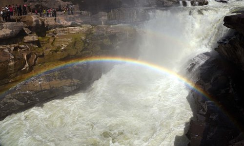
Tourists stand at Hukou Waterfall on the Yellow River to see the new, clean river with a rainbow. Photo: IC

The Yellow River, China's "mother river" known for thousands of years for its heavy concentrations of silt and sediment, is reported to have become permanently clear in some stretches. A rarity in history, the recent phenomenon has aroused fierce discussions and debates between environmentalists and ecologists. A recent report from Outlook Weekly magazine revealed that the Yellow River has become gradually clear, with dwindling sediment concentrations, starting in the year 2000. The river is now clean in the 1200-kilometer middle portion of the river, between Hohhot, Inner Mongolia Autonomous Region, and Taohuayu, Henan Province, which is the cut-off point between midstream and downstream.

It means that, together with the clear upstream, 80 percent stretches of the river are now totally clear in non-flood seasons. Throughout history, there have only been 43 reported instances of the Yellow River becoming clear. And yet, this clarity never lasted more than 20 days. The new phenomenon, which has lasted for years, is the longest duration in its history. This, of course, has excited experts, as it is considered the successful result of several generations worth of consistent efforts in "harnessing" the river, be it vegetation conservation or controlling silt and sediment, which can be traced back to 1946. But considering the environmental significance of the Yellow River, the difficulty in taming it and the potential dangers it still poses, there is no definitive consensus about whether this new clarity is a good or bad thing. Experts have reached a general consensus regarding the reasons for the new clarity, but they still hold different views as to how it will affect the environment in and around the river and other possible risks.


Reduced sediment

Compared with the 43 other times that the Yellow River has become clear, experts agree that those were probably accidental. Today's clarity is something altogether different and dramatic. But the Yellow River's new-found clarity is being attributed to China's ongoing efforts to conserve soil and water and the widespread use of reservoirs, experts have analyzed. For centuries if not millennia, the Yellow River carried 1.6 billion tons of sand on average every year. But between 2000 and 2015, the number suddenly dropped to 264 million. The upstream conservation of soil and water along the Loess Plateau played a significant role in this.

Sword of Damocles

There is also disagreement over how long the Yellow River will stay clear. Qi Pu, who used to be an engineer for the YRCC, believes it will become a trend for the Yellow River to become clear now that sand flow has been dwindling year on year.

For the full article, please visit Global Times: 

Wednesday, January 24, 2018

Mechanism of Efficient Sediment Transport by Hyperconcentrated Flow in the Lower Yellow River

The  Yellow  River, the second largest river in China, is well known as a  highly sediment-laden river. The average annual sediment inflow entering the Lower Yellow River (Figure 1) is 1.6 billion tons. Every year, there are around 400 million tons of sediment deposit on the lower reach of the Yellow River, which results in raising of river bed with  a speed of 10 cm per year. For decades, reduction of channel sedimentation has drawn the attention of hydraulic engineers and geomorphologists (Xu, 2003). In 1950, Soil-Water Conservation Project was initialized to control erosion in the Loess Plateau of the middle basin, which contributes 90% of the sediment loads. However, this project cannot completely solve the sediment problem, since there will be still 800 million tons of sediment yields annually after the project is finished (Qi and Li, 1996). As early as the 1960s, the hyper-concentrated flow occurring on the Loess  Plateau has been field investigated by hydraulic engineers.  The research on the hyper-concentrated flow of the Yellow River, which was originated by Dr. Ning Chien (Chien and Wan, 1999) in 1950’s, opens a new path by making full use of the channel for sediment transport. It has been evolved from pure theory into real engineering practices in recent years. 


In the first  International Workshop on Hyperconcentrated Flow held in Beijing in 1985, scientists from the United States reported on the sediment transportation by lahars and hyper-concentrated flows at Mount St. Helens, Washington (Scott and Dinehart, 1985, Janda and Meyer, 1985, Pierson and Scott, 1985). Brown (1988) advanced the understanding of sediment transport of bed material discharged in sand bed channels through the developed theoretical concepts related to the effects of high concentration of suspended sediment of the water-sediment mixture along with a  27-mile reach of the Cowlitz and Toutle Rivers in Washington. Julien and Lan (1991) used a physically based quadratic rheological model to test hyper-concentrated flows with experimental data. The model considers  (1) cohesion between particles;  (2) viscous friction between fluid and sediment particles; (3) impact of particles; and (4) turbulence. The resulting quadratic formulation of the shear stress was shown to be in excellent agreement with the experimental data sets. Rickenmann (1991) simulated fine-material slurry of a debris flow in a steep flume. The results showed that viscous effects became important below a limiting particle Reynolds number of about 10. Above this limiting value, density effects cause an increase in the bed-load transport rates as compared to similar conditions with clear water as transporting fluid. In the book authored by Wang and Wan  (1994), the rheological properties of hyperconcentrated flows were further revealed, as well as the mechanism of surface instability and drag reduction. Batalla et al.  (1999) analyzed the hyper-concentrated flow occurred after collapsing of a bridge in the Pyrenean Arás basin, Spain. The flood was characterized by transportation of large amounts of slope material, including debris flows.  Along the main tributary, an intensive hyperconcentrated flow was observed during the rising stage, whereas in the main valley smaller flows occurred after the failure of check dams. Lavigne and Suwa  (2004) carried out observation of debris flows, hyperconcentrated flows, and stream flows in the Curah Lengkong River on the southeast slope of Mount Semeru in East Java, Indonesia. This study provided quantitative data for these flows in motion, and it also compared the data for different types of flow that occur in the same river. The influence of rainfall on debris flows, hyperconcentrated flows,  and streamflow generation was also analyzed. A  detailed case  study  in  a  small  catchment  on  the  Loess  Plateau  conducted  by  Hessel  (2005) indicated  that  a  number  of  corrections  are  necessary  to  be  able  to  compare  field measurements  with  results  of  soil  erosion  models:  sediment  volume  should  be subtracted from runoff volume and a density correction is needed to use data from a pressure transducer.