Statement from JMT – “Thank you for selecting the Upper Little Patuxent River Stream Restoration Design Build Project as a Winner of the Environmental Excellence Award. This project is an excellent example of using the MSHA Partnering procedures during the Design Build process to increase environmental benefits, reduce costs and accelerate the completion of project. Johnson, Mirmiran and Thompson, Inc. was fortunate to have been given the opportunity to work for Ecotone, Inc. along with their subconsultant, NMP Engineering Consultant, Inc. on this design build project. The entire Design Build Team developed a great relationship with our SHA teaming partners and our Howard County teaming partners.”
Wednesday, April 15, 2015
My Project - Upper Little Patuxent River Stream Restoration Project Won the Environmental Excellence Award!
The Office of Environment, Maryland Department of Transportation (MDOT) Headquarters selected the Patuxent River Stream Restoration Project for its Environmental Excellence Award. I was the lead water resources engineer working on the hydrologic and hydraulic modeling using GISHydro and HEC-RAS analysis during my employment with NMP Engineering Consultants in Cockeysville, Maryland from March 2013 to September 2013.
Wednesday, March 25, 2015
Hukou Waterfall on the Middle Reach of Yellow River
The Hukou Waterfall (simplified Chinese: 壶口瀑布; traditional Chinese: 壺口瀑布; pinyin: Hǔkǒu Pùbù), the largest waterfall on the Yellow River, China, the second largest waterfall in China (after the Huangguoshu Waterfall), is located at the intersection of Shanxi Province and Shaanxi Province, 165 km (103 mi) to the west of Fenxi City, and 50 km (31 mi) to the east of Yichuan. The Hukou Waterfall exists where water in the middle reaches of the Yellow River flows through Jinxia Grand Canyon. The width of the waterfall changes with the season, usually 30 metres (98 ft) wide but increasing to 50 m (164 ft) during flood season. It has a height of over 20 m (66 ft). When the Yellow River approaches the Hukou Mountain, blocked by mountains on both sides, its width is abruptly narrowed down to 20 m (66 ft) - 30 m (98 ft). The water's velocity increases, and then plunges over a narrow opening on a cliff, forming a waterfall 15 m (49 ft) high and 20 m (66 ft) wide, as if water were pouring down from a huge teapot. Hence it gets the name Hukou (literally, "flask mouth") Waterfall.
Just below the waterfall, there is a shining stone called guishi (鬼石). What makes the stone mysterious is that it moves up and down according to the water level. No matter how large the water volume, it is still at least partly visible.
In the middle of the river, about 3,000 m (9,843 ft) from the Hukou Waterfall, an enormous rock catches the attention of visitors. When the Yellow River flows to this point, divides into two, rolling and roaring on and on from both sides of the rock before reconverging.
Beneath the waterfall is the Qilangwo Bridge which connects the two provinces of Shanxi and Shaanxi. In the sunshine, the mist is refracted by sunlight to create a rainbow spanning the water like a colorful bridge. In 1991, Hukou Waterfall was named one of the "40 Best" national scenic spots.
Due to its awkward location in the Loess Plateau hinterlands, Hukou was once very difficult to access. After the local government improved transport and tourist facilities, the number of tourists rose from 20,000 in 1994 to 47,000 in 1995. The figure for 1996 reached 100,000 tourists.
An image of the Hukou Waterfall can be seen on the older fourth series of the renminbi 50 RMB banknote.
Wednesday, February 25, 2015
Construction of Xiaolangdi Reservoir on Lower Yellow River
Located 25 miles north of the ancient city of Luoyang, the Xiaolangdi Reservoir Dam is the largest project on the Yellow River, second largest hydropower station to the Three Gorges project on the Yangtze River. Constructed in 1994, Xiaolangdi Dam regulates water and silt flow annually. The Dam is a multifunction project designed for flood control, ice control, dredging, industrial and municipal water supply, and hydroelectric power generation. It has a total installed capacity of 1,836 MW and generates up to 5.1 TWh annually with the help of six 306 MW turbines. The dam stands 154 m (505 ft) tall and 1,317 m (4,321 ft) wide, and cost US$3.5 billion to construct.
The scenic area around the dam also acts as a famous tourist attraction of Luoyang. Each year, numerous visitors are attracted to visit the dam as well as the beautiful landscape of the scenic area. The Xiaolangdi scenic area consists of 4 parts, respectively Xitan scenic area, the dam scenic area, Zhangling peninsula scenic area, and the Three Gorge scenic area. The world wide renowned Xiaolangdi Reservoir Dam is just located inside the dam scenic area.
Thursday, January 15, 2015
Humans Have Been Messing With China's Yellow River for 3,000 Years (SMITHSONIAN)
When humans try to tame nature things rarely go according to plan.....
By Rachel Nuwer, SMITHSONIAN.COM,
In China, people sometimes refer to the Yellow River as the River of Sorrow or the Scourge of the Sons of Han. The river is Asia's second-longest and is infamous for its unpredictable and oftentimes devastating floods. However, scholars also believe that it was the birthplace of Chinese civilization, proving the resources that culture needed to flourish. Now, evidence has emerged that for nearly as long as humans have been taking advantage of the Yellow River's resources, they have also been altering its natural course. Beginning around 3,000 years ago, researchers found, people living along the Yellow River started building levees and other flood mitigation systems. As populations increased, alterations to the river became more and more extreme.
The team arrived at this conclusion after analyzing 50 feet of soil layers from an archeological site, which radiocarbon dating confirmed represents about 10,000 years of history. They found the that the sediment deposition rate had increased—a tell-tale sign of human expansion in the area, which causes erosion—and also analyzed the soil for chemical signatures indicative of major changes in the area. By 2,000 years ago, they report, the river had been altered so much that it hardly resembled the natural system of 1,000 years before. "It's easy to see the trap they fell into: building levees causes sediments to accumulate in the river bed, raising the river higher, and making it more vulnerable to flooding, which requires you to build the levee higher, which causes the sediments to accumulate, and the process repeats itself," the researchers say in a statement. "The Yellow River has been an engineered river — entirely unnatural — for quite a long time."
The river, however, was far from tame. A massive flood around AD 14 cost the lives of approximately 9.5 million people, the researchers say, and seemed to have marked the beginning of the end for the Western Han Dynasty. Devastating Yellow River floods continued to be the norm throughout Chinese history, and today, massive dams and dykes occur along the river to try to contain it. "To think that we can avoid similar catastrophe today due to better technology is a dangerous notion," the researchers say. "Unlike ancient China, where human mistakes devastated a single river valley, we now have the technology to make mistakes that can cause devastation on a truly global scale."
Wednesday, December 24, 2014
Tuesday, November 18, 2014
Monday, October 20, 2014
Researchgate Homepage of Pu Qi and Honghai Qi
Please visit Pu Qi's RG Homepage at: http://www.researchgate.net/profile/Pu_Qi, 12 publications including preview of my recent book can be downloaded.
Please visit Honghai Qi's RG Homepage at: http://www.researchgate.net/profile/Honghai_Qi
21 publications can be downloaded.
Wednesday, August 27, 2014
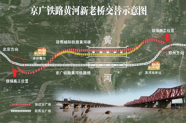
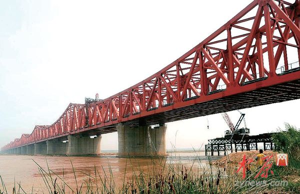
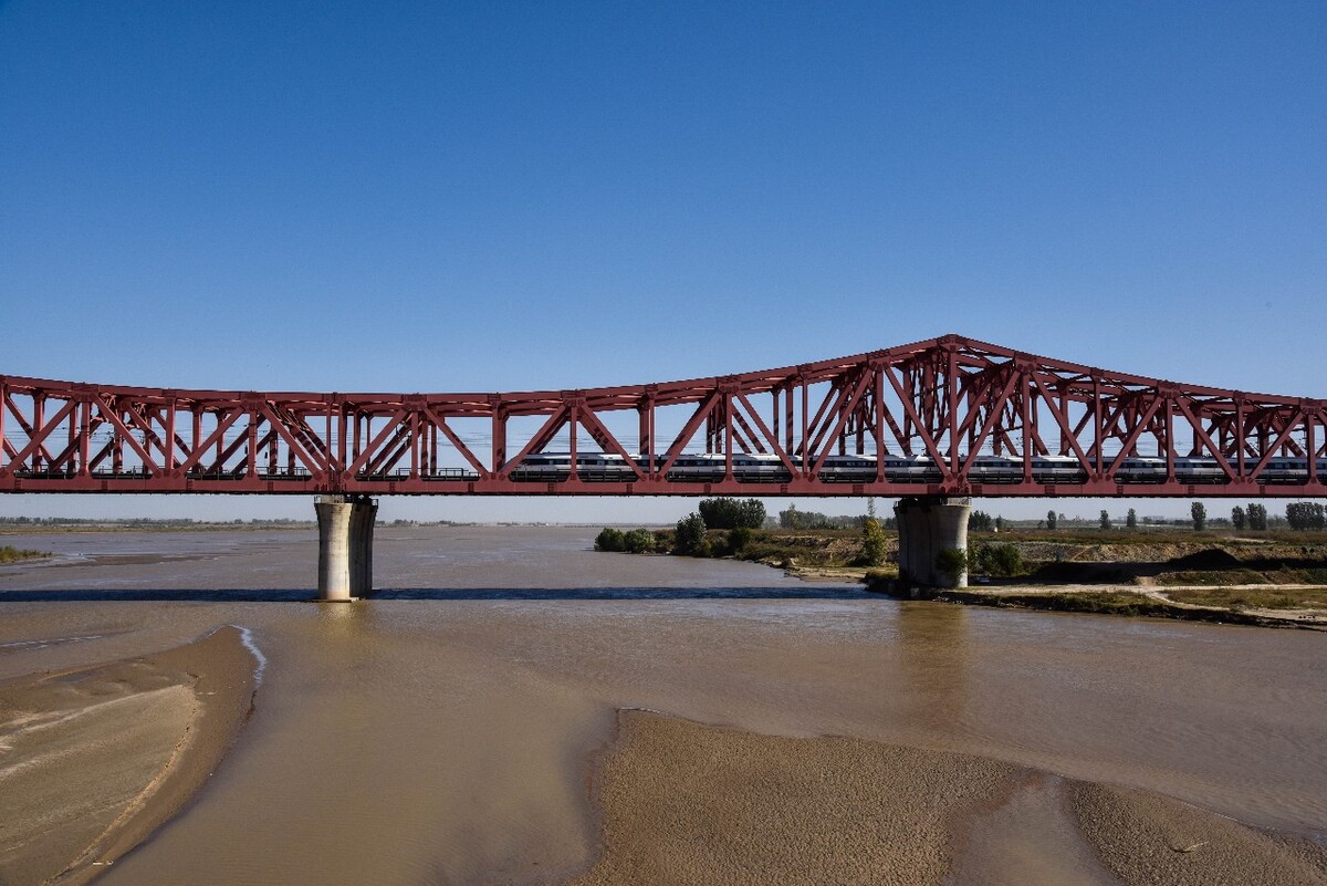
Yellow River's Four-lane Railroad Bridge Opens
ZHENGZHOU, May 16 (Xinhua News) -- The first four-lane railway bridge over the Yellow River, China's second longest, was put into operation on Friday, replacing a two-lane construction which had been in service since 1960.The new bridge in Zhengzhou, capital of central Henan Province, is about 100 meters away from the old one. The 2,200-meter-long bridge is resistant to big floods and has a life span of 100 years, said Cheng Xiang'en, a local railway bridge official. Transfer from the old bridge to the new one caused suspension to the Beijing-Guangzhou railway for four hours 30 minutes and affected 45 trains. Two lines of the bridge are for Beijing-Guangzhou railway while the other two are for intercity trains between Zhengzhou and Jiaozuo, a city in Henan. The designed speed for trains from Beijing to Guangzhou on the new bridge is 160 km per hour, compared with 110 km per hour for passenger trains and 55 km per hour for cargo trains on the old bridge. The designed speed for Zhengzhou-Jiaozuo intercity trains on the bridge is 250 km per hour. Operation of the new bridge will boost capabilities, said Li. Construction of the bridge began in October 2010.


Subscribe to:
Posts (Atom)