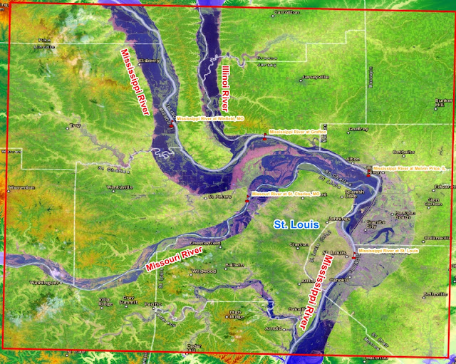
The 1993 Midwest flood was one of the most significant and damaging natural disasters ever to hit the United States. Damages totaled $15 billion, 50 people died, hundreds of levees failed, and thousands of people were evacuated, some for months. The flood was unusual in the magnitude of the crests, the number of record crests, the large area impacted, and the length of the time the flood was an issue.
The paper discusses some details of the flood, the forecasting procedures utilized by the National Weather Service and the precipitation events which caused the flood.
From May through September of 1993, major and/or record flooding occurred across North Dakota, South Dakota, Nebraska, Kansas, Minnesota, Iowa, Missouri, Wisconsin, and Illinois. Fifty flood deaths occurred, and damages approached $15 billion. Hundreds of levees failed along the Mississippi and Missouri Rivers.
The magnitude and severity of this flood event was simply over-whelming, and it ranks as one of the greatest natural disasters ever to hit the United States. Approximately 600 river forecast points in the Midwestern United States were above flood stage at the same time. Nearly 150 major rivers and tributaries were affected. It was certainly the largest and most significant flood event ever to occur in the United States (Fig. 1).
A Depth Grid is GIS format
data that represents the extent of riverine flooding or coastal storm surge inundation and the depth of water at a
given location. Depth Grids are commonly delivered in raster ESRI GRID format,
each pixel contains a value
representing potential water depth. Factors that contribute to the resolution
or level of detail displayed by a depth
grid are twofold. These factors include resolution of your terrain data, and
availability of flood surface elevation
information.
Depth Grid accuracy is
dependent on the resolution of the Digital Elevation Model (DEM) or terrain
data used during the processing of a
Depth Grid. Secondly, the method used for collecting information on the
elevation of your flood surface may vary.
Common methods for generating flood surface information are: the use of High Water Mark (HWM) data, the
use of BFE (Base Flood Elevation) cross sections, or local H&H (Hydrology
and Hydraulics) models. Determining the resolution
requirements for a Depth Grid is reliant on the type of analyses that will be
conducted with the processed Depth
Grid. For example, when site specific (structure by structure) analyses are
needed for loss estimation, higher
resolution elevation datasets are more appropriate, whereas if to gain a
general idea of flood extent is the intent, a
lower resolution elevation dataset would be adequate.


